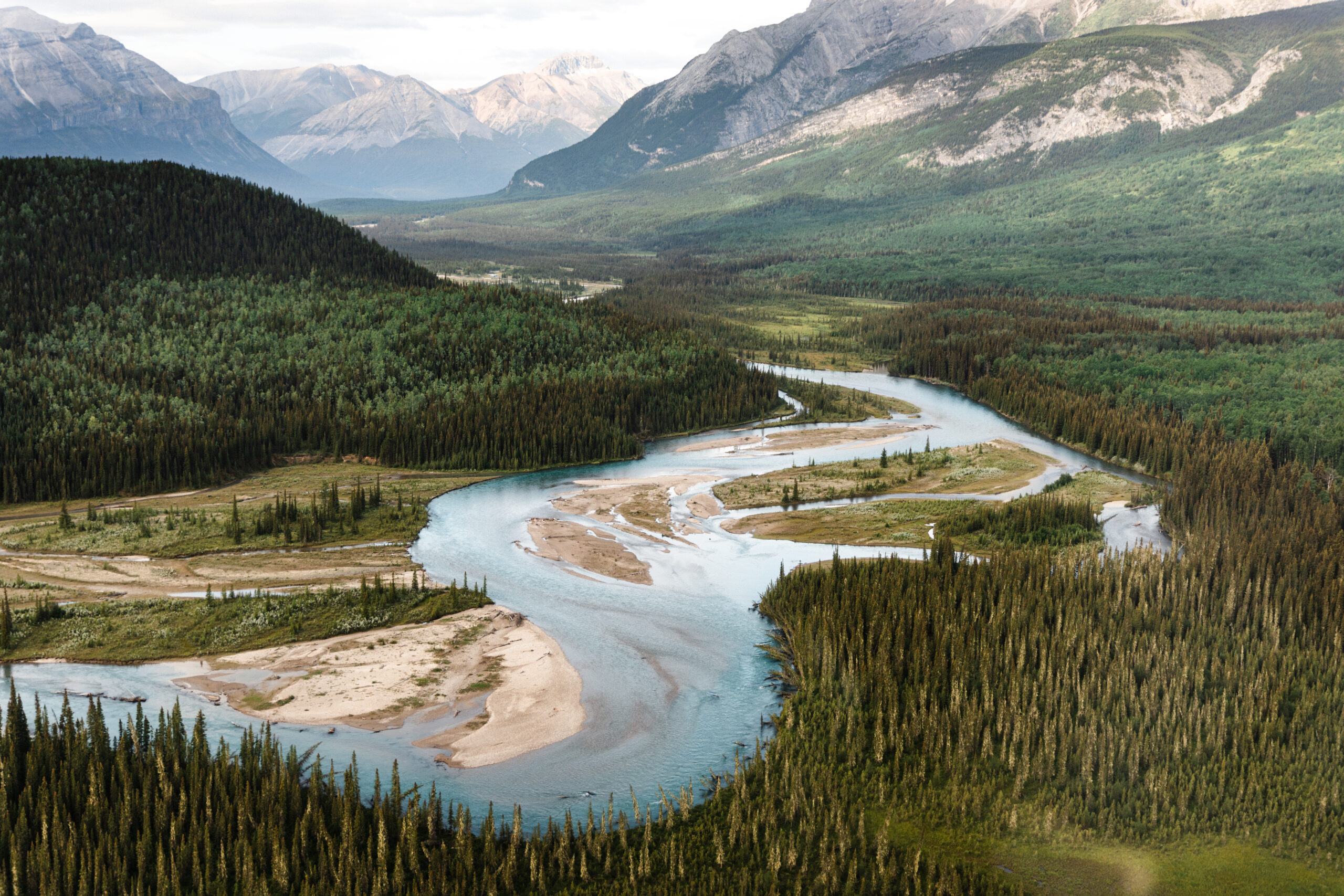
When given adequate protection to thrive, Nature supports healthy wildlife and resilient communities. It’s the common ground that sustains us all.
Yet Nature is at a breaking point and we’re seeing the effects of continued degradation throughout BC. From threatened Grizzly bear populations and dwindling caribou numbers to critically endangered northern spotted owls, biodiversity is declining faster than ever before.
BC to protect 30% of lands by 2030
Good news! In partnership with Indigenous Nations and communities, the BC government has committed to protecting 30% of lands by 2030.
We’ve worked hard to advocate for this commitment, and now it’s time to hold the government accountable to meeting these important targets.
How are we doing?
Protected areas cover 15.6% of the land base in BC, meaning the province will need to nearly double current land protection to meet its 2030 target.
In addition, the BC government includes Other Effective Conservation Measures (OECMs). These are areas that weren’t set aside to protect ecosystems and have often been wrongly included in the tally of total protected areas. A community watershed is a good example of this.
This false accounting adds an extra 4% to reach 19.6%. You can learn more about this from CPAWS-BC’s 2021 report, An Honest Accounting.
Research affirms that biodiversity thrives on lands and protected areas managed by Indigenous Peoples. As stewards of these natural environments since time immemorial, they hold intimate knowledge and understanding of the relationship between land, water, wildlife and people. Indigenous Nations across the province are already taking bold action to address biodiversity loss and conserve ecosystems through Indigenous governance and knowledge systems. New approaches to conservation are being imagined, stewardship initiatives are being launched, and Indigenous Protected and Conserved Areas (IPCAs) are being declared.
Photo: Adam Combs
Did you know? Indigenous Nations can establish IPCAs under their inherent rights and laws, but provincial and federal governments lack the legal frameworks required to recognize them as protected areas.
Supporting Indigenous-led conservation presents an important opportunity for the BC government to increase land protection in a way that upholds Indigenous rights and advances provincial commitments to reconciliation. This includes:
Co-developing protected areas with Indigenous Nations
Establishing a legal framework to recognize IPCAs
Providing continued resources to support Indigenous Guardian programs across BC
Apply Rigorous Standards to all Protected Areas
Not all protected areas in BC are equal. While 15.6% of the province’s landbase is protected by robust designations like provincial parks and conservancies, the other 4.1% claimed as OECMs remains vulnerable to activities that directly harm biodiversity. Unlike protected areas and conservancies, OECMs can be established for objectives outside of conservation as long as management practices provide some level of Nature protection. OECMs must meet clear national and international criteria to be effective, ensuring Nature is adequately protected. This is where BC falls short.
Photo: Adam Combs
Did you know? Old Growth Management Areas (OGMAs) are one of three designations that BC claims as OECMs, and they cover nearly 1.5 million hectares of land. Many OGMAs don’t actually contain old growth forests because they operate as rotating reserves, meaning they are harvested on a rolling 80-year cycle. While industrial activity may be limited to specific areas during certain times, logging, oil, gas and road-building is still permitted in OGMAs, allowing continued destruction of important wildlife habitats.
The BC government needs to scrub its protected area accounting and apply rigorous standards across the board. False reporting inflates BC’s protected areas total and pulls potential away from other proposals and areas that will be more effective at safeguarding biodiversity. Although OECMs that meet the required standards can be valuable in some cases, Indigenous-led conservation and protected areas are the most effective tools to achieve 30% by 2030.
Prioritize Resilient Networks of Protected Lands
Biodiversity is being lost at a staggering rate due to continued habitat destruction. From industrial development to climate change, landscapes around us are constantly changing, forcing animals to move and adapt in new ways. Wildlife needs large, connected landscapes in order to thrive.
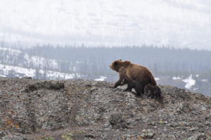
Did you know? There are 55 Grizzly bear populations in BC and 60% of these are threatened with extinction. Grizzly bears rely on large tracts of wild habitats to forage for food throughout different seasons. As they feed and roam from rocky rivers to forest floors, rich nutrients are deposited back into the earth, supporting a much broader network of life.
Natural habitats are shrinking and increasingly fragmented by roads, extraction sites and natural disasters. This leaves wildlife isolated to smaller tracts of wilderness, reducing their access to food sources, breeding potential and safe places to seek refuge. As the keystone Grizzly bear demonstrates, when one species becomes threatened ripple effects are felt throughout entire ecosystems.
As BC develops new protected areas, it’s critical these are strategically established to form larger networks of wilderness landscapes that will serve as wildlife corridors. Protecting large and interconnected lands and waters will place us all on a path to a more resilient and vibrant future.
Support these important landscapes
There are plenty of pathways to achieving 30% by 2030. Explore a few of the unique and important landscapes that will help us better safeguard biodiversity in BC:
Support the sməlqmíx, the syilx people of the Similkameen Valley, in their important work to protect water, restore habitat, and safeguard species within the Ashnola IPCA. [Learn more]
The Gwininitxw Indigenous Protected Area is located in the upper Skeena River watershed and protects 170,000 hectares of critical habitat for mountain goats, wolverines, grizzlies and wild salmon within Wilps Gwininitxw Territory. [Learn more]
Support Kaska Dena’s work to protect Dene Kʼéh Kusān, the largest intact landscape in BC. This proposed Indigenous Protected and Conserved Area (IPCA) would protect nearly four million hectares of wilderness lands abundant with wildlife like caribou, moose and song birds. [Learn more]
The Salmon Parks project initiated and led by the Mowachaht/Muchalaht and Nuchatlaht Ḥaw̓iiḥ (hereditary leaders) is aimed at restoring wild salmon by recovering and protecting key watersheds in Nootka Sound, on Vancouver Island’s west coast. [Learn more]
Nestled between two provincial parks is the Skagit-Manning donut hole, a patch of unprotected land covering about 5,800 hectares. This small but mighty parcel sits at the heart of Skagit Valley and provides vital habitat for spotted owls and Grizzly bears. [Learn more]
A new National Park Reserve in the nxʷəlxʷəltantət (South Okanagan-Similkameen) grasslands will honour the cultural values of the sməlqmix / suknaʔkinx (Okanagan First Nation) and protect about 27,300 hectares of one of the world’s most endangered ecosystems. [Learn more]
Take Action
Nature is in crisis. We are in crisis. To ensure nature and people thrive in the future, all levels of government must address the twin crises of climate change and biodiversity loss.
Here in BC, we need an action plan that prioritizes well-managed, interconnected and Indigenous-led protected areas to achieve 30% protection by 2030.
Send a letter to the BC government and tell them you want to see them work together to support Indigenous-led conservation and protect Nature. BC’s biodiversity and our health depends on it.
Since long before provincial land borders were drawn, the Kaska Dena people have lived in BC’s far north, southeast Yukon, and southern Northwest Territories.
Their ancestral lands extend across a wilderness larger than Vancouver Island. Imagine four million hectares of sweeping wilderness: wild rivers, stretches of alpine, canyons, freshwater lakes. A place with no roads and no power lines, filled with diverse wildlife like caribou, moose and mountain goats. A place where you can walk along ancient Indigenous trails for weeks without meeting another human soul.
Dene Kʼéh Kusān: Protecting more of BC
At the heart of the Kaska’s ancestral lands sits the largest intact landscape in BC: Dene Kʼéh Kusān. It means Always Will Be There.
At CPAWS-BC, we’re working with the Kaska Dena to bring Dene Kʼéh Kusān to life. Together, we want to ensure that the Kaska and their ancestral lands will thrive today and in the future. Together, we’ve built a plan for protecting this vital piece of northern BC, which would add 4% to BC’s protected area percentage. We’re humbled to play a role in this work.
Right Now
In the face of worsening forest fires and severe loss of biodiversity, and in the spirit and practice of reconciliation, we’re asking the federal and BC governments to support the Kaska’s plan for an Indigenous Protected and Conserved Area (IPCA).
This conservation plan builds on existing special management zones inside the Muskwa-Kechika Management Area, designed to sustain and create jobs for Kaska communities and conserve biodiversity. Conservation areas protect animals, plants, and cultural places while minimizing overlap with existing mining, oil, and gas extraction sites.
This plan asks governments to ensure Kaska Territory:
Does not suffer the devastating effects of climate change and biodiversity loss we’re seeing across BC, Canada and around the world
Remains intact, which is critical to preserving Kaska peoples’ material, cultural and spiritual lives
Continues to shelter seven key herds of Whūdzī (Caribou), a species struggling to feed itself and reproduce in other parts of the province
Sustains and creates economic opportunities for Kaska and others in northern communities
Becomes a world-class protected area for British Columbians to explore and enjoy
Creates a climate change safe haven for other at-risk species like Wood Bison, Barn Swallows, Wolverines, Grizzly Bear and more
Take Action
The Kaska Dena are working with partners to protect Dene K’éh Kusān in a way that creates jobs, supports a thriving Kaska culture, shelters threatened species and becomes a world-class Protected Area. Add your name to the Dene K’éh Kusān Statement of Support here.
The Skagit (pronounced ska-dj-ut) donut hole is a 5,800 hectare “hole” in provincial park protection between Manning Park and Skagit Valley Provincial Park. Skagit River’s sparkling headwaters and lush forests are home to hundreds of animals, including 200 bird species, chinook salmon (an orca food staple), and already struggling Grizzly bears. People on both sides of the Canada/US border love this area, too—it’s important to the Upper Skagit, Stó:lō, Syilx and Nlaka’pamux Peoples, and beloved by one million outdoor enthusiasts who hike, fish, ski, snowshoe, paddle, and horseback ride here every year.
For years, the Skagit donut hole has been under attack from logging and mining companies who want to develop and destroy it. Already, logging has carved holes into the landscapes that will take decades to re-green.
We need to protect this special place before it’s too late.
GOOD NEWS
Thanks to the hard work of several groups including CPAWS-BC, the BC Minister of Forests and Minister of Environment announced that logging would be banned in Silverdaisy and 26 Mile valleys in December 2019.
In January 2022, CPAWS-BC celebrated a huge win when the BC government announced that Imperial Metals—the company that has held mining tenures in the donut hole—had surrendered their rights to the area.
This announcement comes off the heels of relentless efforts by an international coalition made up of nearly 300 conservation and recreation organizations, Tribes and First Nations, elected officials and local businesses, as well as over 6,000 individuals, who have opposed Imperial Metals’ application to mine in the Skagit for years.
TIMELINE
1995: Donut hole formed by creation of Skagit Valley Provincial Park and adjustments to the boundaries of Manning Provincial Park
2018: Clearcut logging begins in donut hole
2019: Imperial Metals’ files gold mining application for Skagit headwaters (in donut hole)
2019: Woohoo! BC bans logging in donut hole
2022: Woohoo! Imperial Metals surrenders mining rights in donut hole
RIGHT NOW
With a dam, mining, and logging out of the Skagit donut hole, it’s time for the BC government to work closely with local First Nations to fully protect it.
With its semi-arid deserts of fragrant sagebrush, and its valleys dotted with ponderosa pine, the nxʷəlxʷəltantət (South Okanagan-Similkameen) grasslands are a place where birds like the Flammulated Owl soar, and North American Badgers burrow to build their homes. In the coming years, these animals—along with over 200 other red listed species in BC—will be better protected through a new National Park Reserve (NPR) that will bring several smaller protected areas together into one continuous park.
Grasslands are one of the most endangered ecosystems in the world. Protecting these grasslands should be a top priority—doing so will honour the cultural values of the sməlqmix / suknaʔkinx (Okanagan First Nation), slow species extinction, keep huge amounts of carbon stored in the ground, and provide meaningful recreation opportunities through birdwatching, hiking and more. It would also boost local economies in nearby communities like Osoyoos and Oliver.
GOOD NEWS
After nearly 20 years of hard work from local communities and CPAWS-BC advocating for protection in the South Okanagan-Similkameen, three levels of government—the syilx/Okanagan Nation, provincial, and federal–signed iʔ sc̓ax̌ʷtət, a Memorandum of Understanding (MOU) to begin formal work on establishing a National Park Reserve (NPR) in the area. This park would span 27,300 hectares and protect dozens of species that need our help.
TIMELINE
2003: Canada and BC sign an MOU to assess the feasibility of an NPR in the South Okanagan 2012: Okanagan First Nation completes feasibility study for potential park
2017: Okanagan Nation Alliance, Canadian and BC governments renew promise to create park
2018: Consultations on park begin
2019: Woohoo! MOU signed to solidify commitment to park
2020: Negotiations begin
RIGHT NOW
Currently, negotiations between the syilx/Okanagan Nation, BC, and Canada are underway: this process can take up to four years. In an August 2021 newsletter, Parks Canada noted that no new mining or logging ventures could take place until a final decision on park establishment is made.
Stay in the loop! Subscribe for the latest campaign updates, action alerts and more right to your inbox.

")


")


