When given adequate protection to thrive, Nature supports healthy wildlife and resilient communities. It’s the common ground that sustains us all.
Yet Nature is at a breaking point and we’re seeing the effects of continued degradation throughout BC. From threatened Grizzly bear populations and dwindling caribou numbers to critically endangered northern spotted owls, biodiversity is declining faster than ever before.
BC to protect 30% of lands by 2030
Good news! In partnership with Indigenous Nations and communities, the BC government has committed to protecting 30% of lands by 2030.
We’ve worked hard to advocate for this commitment, and now it’s time to hold the government accountable to meeting these important targets.
How are we doing?
Protected areas cover 15.6% of the land base in BC, meaning the province will need to nearly double current land protection to meet its 2030 target.
In addition, the BC government includes Other Effective Conservation Measures (OECMs). These are areas that weren’t set aside to protect ecosystems and have often been wrongly included in the tally of total protected areas. A community watershed is a good example of this.
This false accounting adds an extra 4% to reach 19.6%. You can learn more about this from CPAWS-BC’s 2021 report, An Honest Accounting.
Research affirms that biodiversity thrives on lands and protected areas managed by Indigenous Peoples. As stewards of these natural environments since time immemorial, they hold intimate knowledge and understanding of the relationship between land, water, wildlife and people. Indigenous Nations across the province are already taking bold action to address biodiversity loss and conserve ecosystems through Indigenous governance and knowledge systems. New approaches to conservation are being imagined, stewardship initiatives are being launched, and Indigenous Protected and Conserved Areas (IPCAs) are being declared.
Photo: Adam Combs
Did you know? Indigenous Nations can establish IPCAs under their inherent rights and laws, but provincial and federal governments lack the legal frameworks required to recognize them as protected areas.
Supporting Indigenous-led conservation presents an important opportunity for the BC government to increase land protection in a way that upholds Indigenous rights and advances provincial commitments to reconciliation. This includes:
Co-developing protected areas with Indigenous Nations
Establishing a legal framework to recognize IPCAs
Providing continued resources to support Indigenous Guardian programs across BC
Apply Rigorous Standards to all Protected Areas
Not all protected areas in BC are equal. While 15.6% of the province’s landbase is protected by robust designations like provincial parks and conservancies, the other 4.1% claimed as OECMs remains vulnerable to activities that directly harm biodiversity. Unlike protected areas and conservancies, OECMs can be established for objectives outside of conservation as long as management practices provide some level of Nature protection. OECMs must meet clear national and international criteria to be effective, ensuring Nature is adequately protected. This is where BC falls short.
Photo: Adam Combs
Did you know? Old Growth Management Areas (OGMAs) are one of three designations that BC claims as OECMs, and they cover nearly 1.5 million hectares of land. Many OGMAs don’t actually contain old growth forests because they operate as rotating reserves, meaning they are harvested on a rolling 80-year cycle. While industrial activity may be limited to specific areas during certain times, logging, oil, gas and road-building is still permitted in OGMAs, allowing continued destruction of important wildlife habitats.
The BC government needs to scrub its protected area accounting and apply rigorous standards across the board. False reporting inflates BC’s protected areas total and pulls potential away from other proposals and areas that will be more effective at safeguarding biodiversity. Although OECMs that meet the required standards can be valuable in some cases, Indigenous-led conservation and protected areas are the most effective tools to achieve 30% by 2030.
Prioritize Resilient Networks of Protected Lands
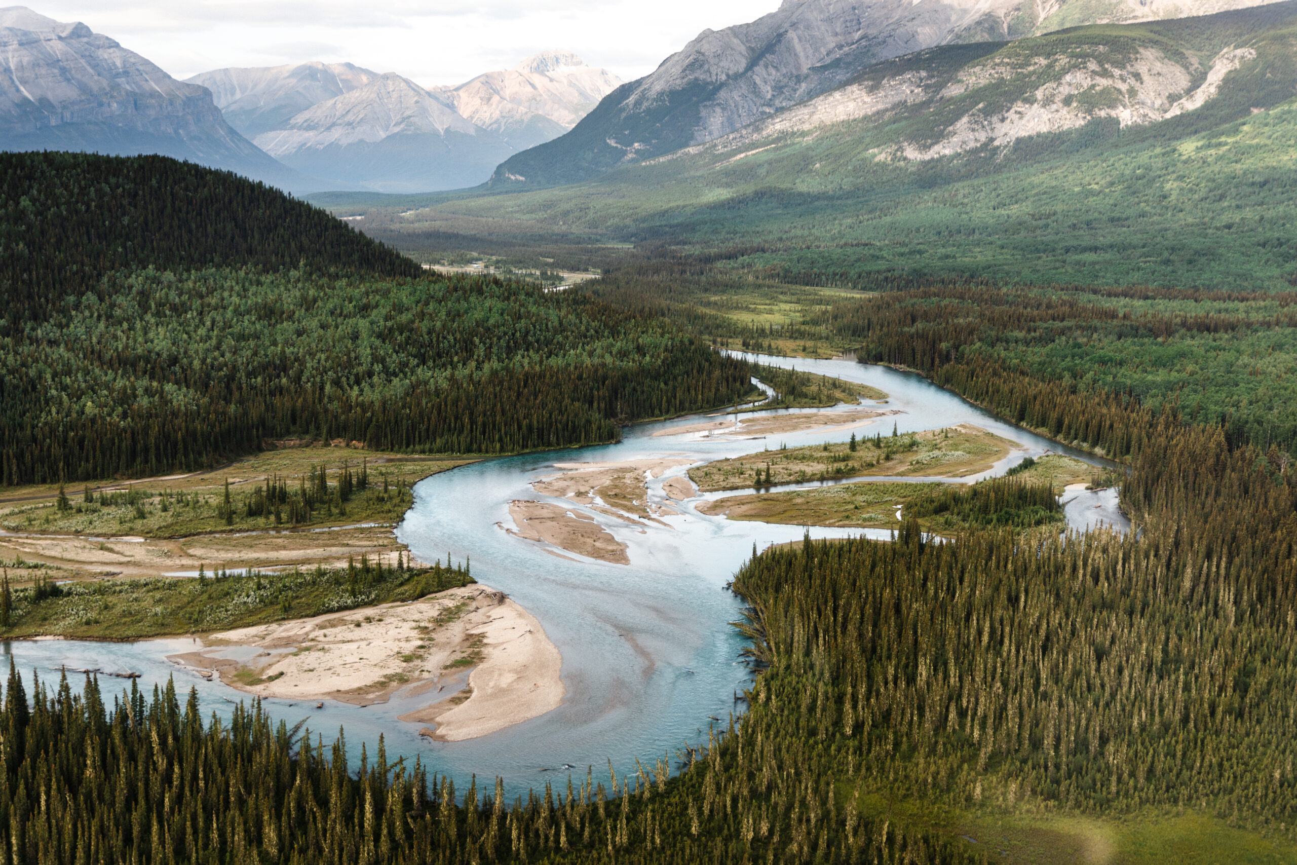
Biodiversity is being lost at a staggering rate due to continued habitat destruction. From industrial development to climate change, landscapes around us are constantly changing, forcing animals to move and adapt in new ways. Wildlife needs large, connected landscapes in order to thrive.
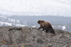
Did you know? There are 55 Grizzly bear populations in BC and 60% of these are threatened with extinction. Grizzly bears rely on large tracts of wild habitats to forage for food throughout different seasons. As they feed and roam from rocky rivers to forest floors, rich nutrients are deposited back into the earth, supporting a much broader network of life.
Natural habitats are shrinking and increasingly fragmented by roads, extraction sites and natural disasters. This leaves wildlife isolated to smaller tracts of wilderness, reducing their access to food sources, breeding potential and safe places to seek refuge. As the keystone Grizzly bear demonstrates, when one species becomes threatened ripple effects are felt throughout entire ecosystems.
As BC develops new protected areas, it’s critical these are strategically established to form larger networks of wilderness landscapes that will serve as wildlife corridors. Protecting large and interconnected lands and waters will place us all on a path to a more resilient and vibrant future.
Support these important landscapes
There are plenty of pathways to achieving 30% by 2030. Explore a few of the unique and important landscapes that will help us better safeguard biodiversity in BC:
Support the sməlqmíx, the syilx people of the Similkameen Valley, in their important work to protect water, restore habitat, and safeguard species within the Ashnola IPCA. [Learn more]
The Gwininitxw Indigenous Protected Area is located in the upper Skeena River watershed and protects 170,000 hectares of critical habitat for mountain goats, wolverines, grizzlies and wild salmon within Wilps Gwininitxw Territory. [Learn more]
Support Kaska Dena’s work to protect Dene Kʼéh Kusān, the largest intact landscape in BC. This proposed Indigenous Protected and Conserved Area (IPCA) would protect nearly four million hectares of wilderness lands abundant with wildlife like caribou, moose and song birds. [Learn more]
The Salmon Parks project initiated and led by the Mowachaht/Muchalaht and Nuchatlaht Ḥaw̓iiḥ (hereditary leaders) is aimed at restoring wild salmon by recovering and protecting key watersheds in Nootka Sound, on Vancouver Island’s west coast. [Learn more]
Nestled between two provincial parks is the Skagit-Manning donut hole, a patch of unprotected land covering about 5,800 hectares. This small but mighty parcel sits at the heart of Skagit Valley and provides vital habitat for spotted owls and Grizzly bears. [Learn more]
A new National Park Reserve in the nxʷəlxʷəltantət (South Okanagan-Similkameen) grasslands will honour the cultural values of the sməlqmix / suknaʔkinx (Okanagan First Nation) and protect about 27,300 hectares of one of the world’s most endangered ecosystems. [Learn more]
Take Action
Nature is in crisis. We are in crisis. To ensure nature and people thrive in the future, all levels of government must address the twin crises of climate change and biodiversity loss.
Here in BC, we need an action plan that prioritizes well-managed, interconnected and Indigenous-led protected areas to achieve 30% protection by 2030.
Send a letter to the BC government and tell them you want to see them work together to support Indigenous-led conservation and protect Nature. BC’s biodiversity and our health depends on it.
Between Vancouver and Victoria lie the emerald waters of the Southern Strait of Georgia, home to most endangered marine mammals in Canada– the Southern Resident killer whales. Southern Resident orca critical habitat has been identified in the area, where they feed on extreme dwindling numbers of their favored chinook salmon.
The legacy of thriving orca echoes through stories told across the surrounding Salish Sea where, in 2023 only 75 remain. Precariously low numbers of their favoured Chinook salmon and noise from marine transportation affect their hunting. While interim and seasonal measures have been put in place to increase food availability and decrease human disturbance, they need permanent protections if there is to be any chance of their survival.
The planned NMCAR would include critical feeding habitat for endangered Southern Resident killer whales.
HOME OF THE ORCAS
Between Vancouver and Victoria lie the emerald waters of the Southern Strait of Georgia, home to most endangered marine mammals in Canada– the Southern Resident killer whales. Southern Resident orca critical habitat has been identified in the area, where they feed on extreme dwindling numbers of their favored chinook salmon.
The legacy of thriving orca echoes through stories told across the surrounding Salish Sea where now a mere 75 remain. Precariously low numbers of their favoured Chinook salmon and noise from marine transportation affect their hunting. While interim and seasonal measures have been put in place to increase food availability and decrease human disturbance, they need permanent protections if there is to be any chance of their survival.
The planned NMCAR would include critical feeding habitat for endangered Southern Resident killer whales.
BIODIVERSITRY HOTSPOTS
The Southern Strait of Georgia is more than just the home of the Southern Resident orcas. More than 3,000 species can be found here seasonally and year-round. These include the Bigg’s transient killer whales, the Pacific giant octopus — the world’s largest, 100-year-old rockfish, schools of herring and salmon, millions of birds, as well as seals and sea lions, dolphins and whales. The region also contains climate change fighting, biodiverse habitats like seagrass beds and glass sponge reefs.
The shores of the Salish Sea and the many islands within it have sustained Indigenous Peoples for generations. The incredible natural beauty and abundance of life led scientists, including world-renowned ocean explorer Jacques Cousteau, to call for its protection back in 1970.
In 2003, Parks Canada and the provincial government began working to establish the Southern Strait of Georgia National Marine Conservation Area Reserve (NMCAR), but two decades later, the area is still not protected.
BIODIVERSITY HOTSPOTS
The Southern Strait of Georgia is more than just the home of the Southern Resident orcas. More than 3,000 species can be found here seasonally and year-round. These include the Bigg’s transient killer whales, the Pacific giant octopus — the world’s largest, 100-year-old rockfish, schools of herring and salmon, millions of birds, as well as seals and sea lions, dolphins and whales. The region also contains climate change fighting, biodiverse habitats like seagrass beds and glass sponge reefs.
The shores of the Salish sea and the many islands within it have sustained Indigenous Peoples for generations. The incredible natural beauty and abundance of life led scientists, including world-renowned ocean explorer Jacques Cousteau, to call for its protection back in 1970.
In 2003, Parks Canada and the provincial government began working to establish the Southern Strait of Georgia National Marine Conservation Area Reserve (NMCAR), but two decades later, the area is still not protected.
THESE WATERS ARE OVERDUE FOR PROTECTION
Right now local First Nations are working with Parks Canada on the feasibility of an NMCAR to protect these waters. Co-development and co-management will ensure that the vision and stewardship values of the 11 First Nations who share these waters are at the heart of plans to protect these waters. We expect updates this summer on the status of the process and how you can share your support for protecting the home of the orcas.
<
THESE WATERS ARE OVERDUE FOR PROTECTION
Right now local First Nations are working with Parks Canada on the feasibility of an NMCAR to protect these waters. Co-development and co-management will ensure that the vision and stewardship values of the 11 First Nations who share these waters are at the heart of plans to protect these waters. We expect updates this summer on the status of the process and how you can share your support for protecting the home of the orcas.
A NATIONAL MARINE CONSERVATION AREA RESERVE
NMCARs are a type of federal marine protected area created by Parks Canada. They focus on ecologically sustainable use — harmonizing conservation with human activities. This involves working closely with those who use the coastal land and the water to create a healthy marine ecosystem.
Human uses such as fishing and shipping, for example, are allowed in national marine conservation areas. But they would be limited or even eliminated from zones protecting sensitive features such as nesting areas, spawning beds, and cultural sites.
Stay Up To Date
Stay up to date with conservation news and learn how you can take action to protect the Home of the Orcas by signing up for our newsletter.
The Great Bear Sea is next to the sacred Great Bear Rainforest. Located off the North and Central Coasts of BC, the area includes Haida Gwaii and the waters around Northern Vancouver Island. Also known as the Northern Shelf Bioregion, these abundant offshore islands, rocky shorelines and deep fjords are home to iconic wildlife. Every summer, migrating humpback whales come to feed in these rich waters. Both Bigg’s and Northern Resident killer whales cruise through the Great Bear Sea. Once hunted to extinction from BC, reintroduced sea otters are bouncing back and helping bring back balance to ecosystems. Healthy kelp forests, seagrass meadows, and glass sponge reefs provide shelter for marine life like rockfish and shrimp. This rich stretch of ocean helps fight climate change by storing blue carbon.
Indigenous Peoples have stewarded the Great Bear Sea since time before memory. These waters have supported vibrant societies and cultures for thousands of years. Indigenous Peoples continue to lead the stewardship of healthy coastal waters now and for generations to come. Care and respect for nature is woven through many cultural values. Responsible management of the coast ensures sustainable resources and local food security.
Working Together to Create Canada’s First Marine Protected Area Network
Now the dual crises of climate change and biodiversity loss threaten these rich waters’ ability to provide for the future. Overharvesting, destructive fishing, and pollution are mounting pressure and adding excess stress. Marine protected areas can act as an insurance policy to keep marine life healthy in the face of a changing ocean. These designations grant refuge from harmful human activities. When we protect the oceans, we’re not only protecting nature. We’re also supporting healthy, sustainable, local economies along the coast.
For over a decade, 17 First Nations in partnership with the federal and provincial governments, have been working together to create Canada’s first network of marine protected areas to safeguard the Great Bear Sea. The MPA network aims to protect marine wildlife and First Nations’ cultural conservation priorities.
Existing marine protected areas potential for a connected marine protected areas in the Great Bear Sea
Now it’s time for us all to connect the dots. We’ve seen MPA networks work in other parts of the world; now it’s BC’s turn to level up for our coast. By adding many smaller protected areas to neighbouring hotspots, the network can link important marine habitats. The benefits of a single MPA will spillover and amplify beyond the protected borders. MPA networks are more comprehensive and safeguard ocean biodiversity more effectively than individual sites.
Share your Support for Canada’s First MPA Network
Right now we need your help to share support for the completion of the network of marine protected areas. MPAs and networks provide refuge for ocean life to thrive and also benefit people by supporting sustainable industries, local economies, and coastal communities.
Tell the MPA Network partners that the network must have strong protections and meet minimum standards to support both the people and marine life who depend on these waters.
There will be public webinars, open houses and online surveys. Please visit MPAnetwork.ca to learn how you can share your support for the MPA network.
NEW! Learn more about the Great Bear Sea by visiting: ourgreatbearsea.ca
Learn More
Check out our Site by Site series on the Great Bear Sea Marine Protected Area Network
Tang.ɢwan – ḥačxʷiqak – Tsig̱is MPA: A Deepsea Oasis
Thousands of metres beneath the swells of the open ocean west of Vancouver Island is the Tang.ɢwan – ḥačxʷiqak – Tsig̱is (ThT) Marine Protected Area (MPA). This mysterious Deepsea Oasis is teeming with life.
The waters of Tang.ɢwan – ḥačxʷiqak – Tsig̱is have enriched the lives of the Haida, Nuu-chah-nulth, Pacheedaht, Quatsino Peoples for millenia. Pronounced Tung – Gwun, huch/khwi/kuk, tsee-geese, the marine protected area name consists of: – a Haida word meaning deep ocean (Tang.ɢwan), – a Nuu-chah-nulth and Pacheedaht word meaning deepest part of the ocean (ḥačxwiqak), – and a Quatsino word referring to a monster of the deep (Tsig̱is). Whales and seabirds on the ocean surface have long signaled a rich ecosystem below. First Nations are working with Fisheries and Oceans Canada to protect and co-manage their fishing territory.
In these dark waters, seamounts rise 3000 metres above the seafloor, extending higher than Whistler Mountain. These underwater volcanoes are biodiversity hotspots offering a buffet for marine wildlife. Like the Galápagos Islands to the south, each of the nearly 50 identified seamounts is unique, providing critical habitat.
Hydrothermal vents, which are like deep sea hot springs, release superheated water and minerals from under the Earth’s crust. These vents are home to 10 species recorded nowhere else in the world.
Tang.ɢwan – ḥačxʷiqak – Tsig̱is encompasses all of Canada’s hydrothermal vents and 75% of its known seamounts.
A Hotspot for Marine Protection
Canada created its first marine protected area, Endeavour Hydrothermal Vents MPA, in this region in 2003. Tang.ɢwan – ḥačxʷiqak – Tsig̱is MPA would give stronger, permanent marine protection for this Deepsea Oasis – an area four times the size of Vancouver Island.
A Hotspot for Marine Protection
Canada created its first marine protected area (MPA), Endeavour Hydrothermal Vents MPA, in this region in 2003. The proposed Tang.ɢwan – ḥačxʷiqak – Tsig̱is MPA would give stronger, permanent marine protection for the Deepsea Oasis – an area four times the size of Vancouver Island. It would be the biggest protected area of any kind in Canada, and add a welcome boost toward Canada’s commitment of 30% ocean protection by 2030.
TIMELINE
2003 – Endeavour Hydrothermal Vent in BC designated as Canada’s first Marine Protected Area under the Oceans Act (was announced as a pilot MPA in 1998)
2009 – Pacific Offshore listed by the Canadian Science Advisory Secretariat as one of 13 bioregions which inform marine planning exercises including MPA network development
2017 – Fisheries and Oceans Canada declares the Offshore Pacific Bioregion area of interest for a potential MPA
2017 – Marine refuge declared for the large Offshore Pacific area of interest. The Fisheries closure, categorized as an Other-Effective Conservation Measure (OECM) with partial protections, encompasses a number of seamounts and hydrothermal vents – identified as Ecologically and Biologically Significant Areas (EBSAs)
2023: Memorandum of understanding (MOU) between the Haida Nation, Nuu-chah-nulth Tribal Council, Pacheedaht First Nation, Quatsino First Nation, and the Canadian government (MPA) signals final consultation through Canada Gazette to become an MPA
MPA Protection Standards
BC’s rich deep sea ocean life is under threat. Bottom-contact fishing such as longlines, trap fishing, and trawling is highly destructive to the seafloor. Deep sea mining could destroy fragile habitats on seamounts and hydrothermal vents.
Fisheries and Oceans Canada designated a large portion of the current MPA as a fishing closure in 2017, prohibiting bottom-contact fishing. Under the new MPA protection standard ThT now has stronger protections: banning bottom trawling, dumping, oil and gas exploration and deep sea mining.
Hydrothermal vents expel hot plumes of mineral-rich gases. Photo: Ocean Networks Canada (CC BY-NC-SA 3.0)
Meeting MPA Minimum Standards
BC’s rich deep sea ocean life is under threat. Bottom-contact fishing such as longlines, trap fishing, and trawling is highly destructive to the seafloor. Deep sea mining could destroy fragile habitats on seamounts and hydrothermal vents.
Fisheries and Oceans Canada designated a large portion of the Deepsea Oasis as a fishing closure in 2017. This prohibits bottom-contact fishing, but it still allows, other harmful industrial activities. A marine protected area would enforce Canada’s MPA minimum standards: banning bottom trawling, dumping, oil and gas exploration and deep sea mining.
The Sea of Glass: Protecting BC’s unique glass sponge reefs
Deep in the cold dark waters of the BC coast lie rare ecosystems once thought extinct: glass sponge reefs! While individual glass sponges have been identified around the world, glass sponge reefs are mostly unique to beautiful British Columbia. On the north and central coasts, these living reefs stretch for hundreds of kilometres across the seafloor and reach the height of a six story building. Smaller reefs also grow in the Salish Sea on the south coast, just outside Vancouver and Victoria. BC truly has a sea of glass!
Natural Solution to Climate Change
These marine animals are an integral part of a healthy marine habitat. Glass sponge reefs provide shelter for marine life including rockfish and shrimp, store carbon on the ocean floor, filter bacteria out of the water, and fertilize the ocean. The sea of glass supports thriving culture and livelihoods for coastal communities.
With skeletons made of silica, these sponges are extremely fragile. Bottom contact fishing such as bottom trawling and shrimp trapping easily shatter their bodies. Sediment on the seafloor kicked up by these fishing methods also causes them to “choke” and stop feeding.
Glass sponge reefs provide habitat for economically important rockfish and shrimp
Strong Permanent Protection for the Sea of Glass
CPAWS-BC looks to protect the Sea of Glass by calling on the federal government to ban bottom contact fishing on or near glass sponge reefs with marine protected areas (MPAs) and Other Effective Conservation Measures (OECMs) such as marine refuges and fishing closures.
Hecate Strait/Queen Charlotte Sound Glass Sponge Reefs Marine Protected Area
Off the north and central coasts of BC, the Hecate Strait/Queen Charlotte Sound Glass Sponge Reefs Marine Protected Area (MPA) prohibits bottom contact fishing. CPAWS-BC is calling on the federal government to make the MPA bigger because new research shows that sediment from beyond the one kilometre buffer zone, as far away as six kilometres, can cause the sponges to choke.
Strait of Georgia and Howe Sound Glass Sponge Reefs
On the south coast, the marine refuges and fishing closures of the Strait of Georgia and Howe Sound Glass Sponge Reef Conservation Initiative protect the Salish Sea’s glass sponge reefs. While not full marine protected areas, these OECMs prohibit bottom contact fishing. CPAWS-BC is calling on the federal government to make these protections more permanent since the current laws can be removed with a change in ministry leadership. We are also calling for better monitoring and enforcement because after the fact fines do not prevent fishing damage from occurring in the first place.
Stay Up To Date
Stay up to date with conservation news and learn how you can take action to protect BC’s unique glass sponge reefs by signing up for our newsletter.
Since long before provincial land borders were drawn, the Kaska Dena people have lived in BC’s far north, southeast Yukon, and southern Northwest Territories.
Their ancestral lands extend across a wilderness larger than Vancouver Island. Imagine four million hectares of sweeping wilderness: wild rivers, stretches of alpine, canyons, freshwater lakes. A place with no roads and no power lines, filled with diverse wildlife like caribou, moose and mountain goats. A place where you can walk along ancient Indigenous trails for weeks without meeting another human soul.
Dene Kʼéh Kusān: Protecting more of BC
At the heart of the Kaska’s ancestral lands sits the largest intact landscape in BC: Dene Kʼéh Kusān. It means Always Will Be There.
At CPAWS-BC, we’re working with the Kaska Dena to bring Dene Kʼéh Kusān to life. Together, we want to ensure that the Kaska and their ancestral lands will thrive today and in the future. Together, we’ve built a plan for protecting this vital piece of northern BC, which would add 4% to BC’s protected area percentage. We’re humbled to play a role in this work.
Right Now
In the face of worsening forest fires and severe loss of biodiversity, and in the spirit and practice of reconciliation, we’re asking the federal and BC governments to support the Kaska’s plan for an Indigenous Protected and Conserved Area (IPCA).
This conservation plan builds on existing special management zones inside the Muskwa-Kechika Management Area, designed to sustain and create jobs for Kaska communities and conserve biodiversity. Conservation areas protect animals, plants, and cultural places while minimizing overlap with existing mining, oil, and gas extraction sites.
This plan asks governments to ensure Kaska Territory:
Does not suffer the devastating effects of climate change and biodiversity loss we’re seeing across BC, Canada and around the world
Remains intact, which is critical to preserving Kaska peoples’ material, cultural and spiritual lives
Continues to shelter seven key herds of Whūdzī (Caribou), a species struggling to feed itself and reproduce in other parts of the province
Sustains and creates economic opportunities for Kaska and others in northern communities
Becomes a world-class protected area for British Columbians to explore and enjoy
Creates a climate change safe haven for other at-risk species like Wood Bison, Barn Swallows, Wolverines, Grizzly Bear and more
Take Action
The Kaska Dena are working with partners to protect Dene K’éh Kusān in a way that creates jobs, supports a thriving Kaska culture, shelters threatened species and becomes a world-class Protected Area. Add your name to the Dene K’éh Kusān Statement of Support here.
The Skagit (pronounced ska-dj-ut) donut hole is a 5,800 hectare “hole” in provincial park protection between Manning Park and Skagit Valley Provincial Park. Skagit River’s sparkling headwaters and lush forests are home to hundreds of animals, including 200 bird species, chinook salmon (an orca food staple), and already struggling Grizzly bears. People on both sides of the Canada/US border love this area, too—it’s important to the Upper Skagit, Stó:lō, Syilx and Nlaka’pamux Peoples, and beloved by one million outdoor enthusiasts who hike, fish, ski, snowshoe, paddle, and horseback ride here every year.
For years, the Skagit donut hole has been under attack from logging and mining companies who want to develop and destroy it. Already, logging has carved holes into the landscapes that will take decades to re-green.
We need to protect this special place before it’s too late.
GOOD NEWS
Thanks to the hard work of several groups including CPAWS-BC, the BC Minister of Forests and Minister of Environment announced that logging would be banned in Silverdaisy and 26 Mile valleys in December 2019.
In January 2022, CPAWS-BC celebrated a huge win when the BC government announced that Imperial Metals—the company that has held mining tenures in the donut hole—had surrendered their rights to the area.
This announcement comes off the heels of relentless efforts by an international coalition made up of nearly 300 conservation and recreation organizations, Tribes and First Nations, elected officials and local businesses, as well as over 6,000 individuals, who have opposed Imperial Metals’ application to mine in the Skagit for years.
TIMELINE
1995: Donut hole formed by creation of Skagit Valley Provincial Park and adjustments to the boundaries of Manning Provincial Park
2018: Clearcut logging begins in donut hole
2019: Imperial Metals’ files gold mining application for Skagit headwaters (in donut hole)
2019: Woohoo! BC bans logging in donut hole
2022: Woohoo! Imperial Metals surrenders mining rights in donut hole
RIGHT NOW
With a dam, mining, and logging out of the Skagit donut hole, it’s time for the BC government to work closely with local First Nations to fully protect it.

")


")


")


